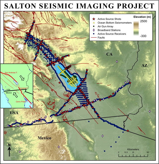
SSIP project map. Red lines are faults; symbols (see index) are seismic sources or seismographs. Inset map shows simplified plate boundary faults.
SSIP project map. Red lines are faults; symbols (see index) are seismic sources or seismographs. Inset map shows simplified plate boundary faults.
Based on the paleoseismic record, the southern San Andreas Fault is considered overdue for an earthquake of magnitude >7.5. Several other faults in the Salton Trough have had historic earthquakes with magnitudes >7. Earthquake hazard models and strong ground motion simulations require knowledge of the dip of the faults and the geometry and wavespeed of the adjacent sedimentary basins, but these parameters are currently poorly constrained.
To address these topics, the Salton Seismic Imaging Project (SSIP) acquired seismic data along and across the Salton Trough in March 2011. The seismic datasets include seven lines of onshore refraction and low-fold reflection data, airguns and OBS data in the Salton Sea, onshore-offshore data, and a line of broadband stations.
The controlled-source data were acquired over three weeks. A total of 33,329 kg of explosives was detonated in 126 explosive shots in plugged boreholes along 7 lines. In addition, a 3.4-liter GI airgun was fired 2330 times along a series of lines in the Salton Sea. The surveys were coordinated so that seismographs recorded both sources.
Onshore, seismographs were obtained from both the EarthScope FlexArray and IRIS PASSCAL instrument pools, with field support from PASSCAL personnel. 2595 "Texan" seismographs with single-component 4.5-Hz geophones were used in 4739 deployments at 3958 unique sites. In addition, 186 RT-130 recorders were deployed at 277 sites with 3-component 4.5-Hz geophones. Land seismographs were deployed at 100-500 m spacing along several lines, and in grids in the valleys. In addition to recording shots and airguns, these instruments frequently recorded continuously to record natural sources and noise.
Offshore seismographs were obtained from the Ocean Bottom Seismograph Instrument Pool (OBSIP). Forty-eight 3-component OBS's were deployed at 78 sites in the Salton Sea along two densely sampled lines and a grid in the southern sea.
About 120 people participated in the data acquisition, about half of whom were students from 31 different colleges and universities. Since data acquisition was during the academic year, many students rotated on 1-week shifts. Over three-quarters of the field crew were volunteers, with travel expenses paid by the project. This crew was so efficient that we returned one more instrument to PASSCAL than their inventory said they sent us!
To complement the controlled-source studies and extend the imaging to greater depth, broadband seismometers were deployed at 5-km spacing across the Salton Trough. The instruments, obtained from PASSCAL, were installed in January 2011 for a planned 18-month deployment. The line is coincident with a crustal-scale refraction-reflection line and recorded the controlled sources. Sixteen people from 5 universities participated in the deployment.
SSIP ultimately will constrain the initiation and evolution of nearly complete continental rifting, including the emplacement of magmatism, effects of sedimentation upon extension and magmatism, and partitioning of strain during continental breakup. To improve earthquake hazard models, SSIP will image the geometry of the San Andreas, Imperial and other faults; structure of sedimentary basins in the Salton Trough; and three-dimensional seismic wavespeed of the crust and uppermost mantle.
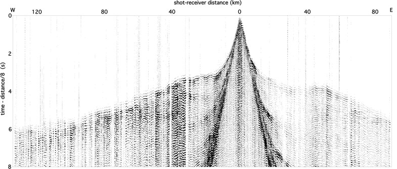
Shot gather. The 911 kg shot was at the Imperial Fault. The 1142 seismograms (from Texans, plus vertical components from RT130's) were recorded along Line 2 that extends from the San Diego and Tijuana suburbs across the Peninsular Ranges, Salton Trough and Chocolate Mountains, to the Colorado River.
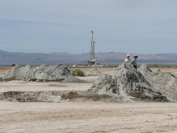
Mud pots in the rift zone. The drill rig in the background is for commercial geothermal energy production.
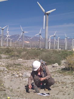
Deploying a Texan seismograph on a wind farm near Palm Springs.
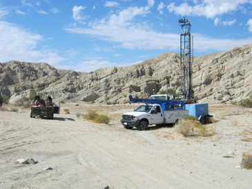
Drilling a seismic shot hole near the San Andreas Fault.
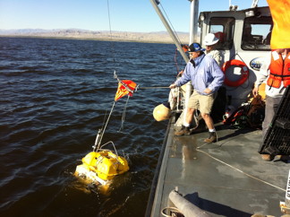
Deploying an OBS into the shallow Salton Sea. The barge vessel was custom built for the OBS and airgun work.
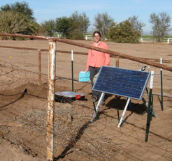
A broadband station deployed on a private farm in the Imperial Valley.
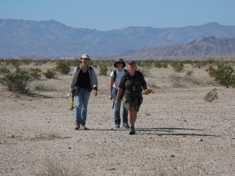
Backpacking seismographs across a Naval bombing range. Each person is carrying ~8 Texan seismographs and deployment equipment.
Project funding:


To John Hole's home page
To Joann Stock's home page
To USGS home page
To Neal Driscoll's home page
To Alistair Harding's home page
To Graham Kent's home page
To Simon Klemperer's home page
To Antonio Gonzalez-Fernandez's home page
To Octavio Lazaro-Mancilla's home page