IDOR Photos
EarthScope Idaho-Oregon 2012 Seismic Refraction / Wide-Angle Reflection Survey
Contacts:
John Hole or
Kathy Davenport at Virginia Tech
IDOR Project site
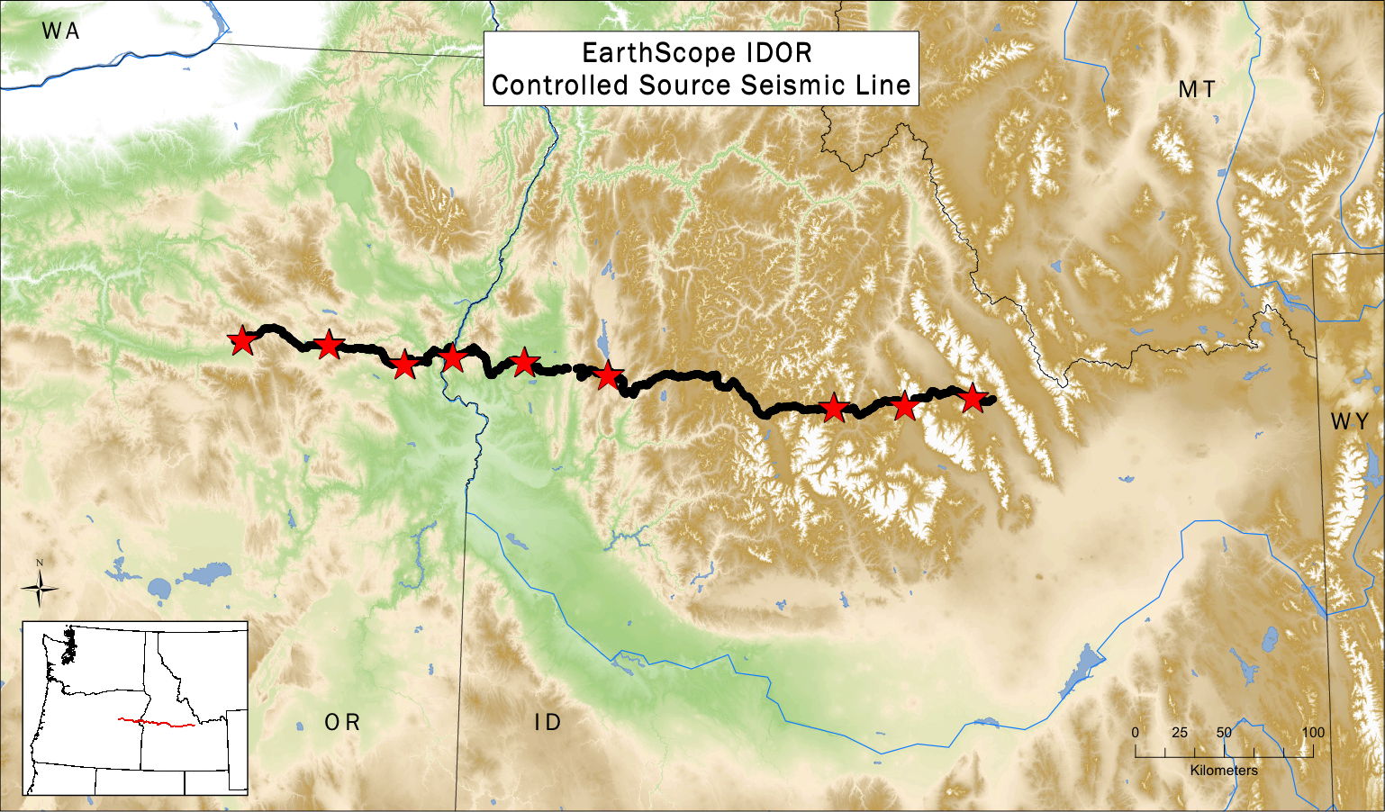
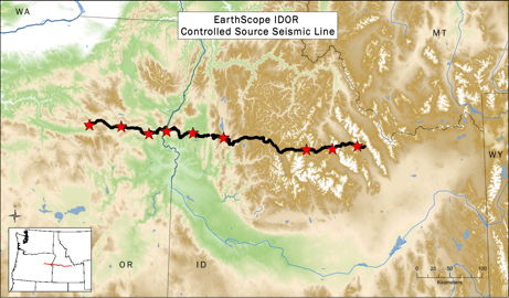 map of controlled-source seismic line
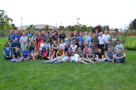 Most of the 61-person IDOR Controlled-Source Seismic crew were volunteers, mostly students, from 22 different universities.
 the shot loading and stemming crew, led by Steven Harder (professor at University of Texas, El Paso), in front of the explosives pump truck
 the survey crew, led by Kathy Davenport (graduate student at Virginia Tech), surveyed the seismometer sites prior to arrival of the deployment crew
 George Slad (staff at IRIS-PASSCAL) training the crew how to deploy a seismometer (ground shaking sensor - orange) and seismomograph (recording unit - in plastic bag; this device is nicknamed a "Texan")
 Strawberry Mountain, near Prairie City, Oregon; these mountains are comprised of island-arc terranes accreted to North America
 Maureen Kahn (undergrad volunteer from Carleton College) deploying a Texan seismograph in eastern Oregon
 Snake River gorge, where the seismic line crosses the Idaho-Oregon boundary
 Messan Folivi (undergrad volunteer from Southern University) deploying a Texan seismograph in western Idaho
 one of two occasions that a vehicle had 2 flat tires simultaneously; it was a ~5-hour walk out in 95-degree sun
 sign in a ranching valley near Midvale, Idaho
 Long Valley, Idaho; the mountains in the background are the Western Idaho Shear Zone
 Ray Russo (IDOR project PI; professor at Univerity of Florida) enjoying the view from Snowbank Mountain, on the Western Idaho Shear Zone
 Rich Gaschnig (postdoc volunteer from the University of Maryland) meeting all Forest Service requirements for road work
 Basil Tikoff (IDOR project PI; professor at University of Wisconsin, Madison) and Annia Fayon (professor at University of Minnesota) teaching the crew about the Idaho Batholith and Western Idaho Shear Zone during a mid-project field trip
 another flat tire, being changed by Lindsay Sabey (Virginia Tech grad student)
 Jennifer All (undergrad volunteer from Radford University) leading a crew of seismometer deployers on a 16-km hike, crossing the Deadwood River, Idaho
 the Sawtooth Mountainns, central ID, in the Idaho Batholith
 the Halstead fire, central Idaho, as viewed from the seismic line; seismometers were not deployed as originally planned along the road in the foreground
 deploying under a menacing cloud of smoke from the Halstead fire, central Idaho
 when picking up the Texan seismographs, one was found under a piece of heavy machinery; it can be seen poking out at the end of the shovel
 the Lost River Valley and Lost River Range, eastern Idaho; this region is actively extending
 Borah Peak in the Lost River Range, eastern Idaho; the range front is the fault scarp of the 1983 magnitude 6.9 Borah Peak earthquake; this fault is actively extending
 bees on a desert flower near the Snake River canyon
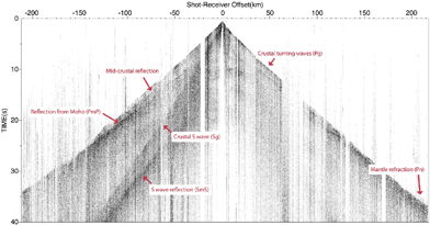 Band-pass filtered data from one shot.
The image shows strong P-wave and S-wave energy that has refracted (turned) in the crust,
energy that has reflected from the mid-crust and the Moho, and energy that has refracted in the uppermost mantle.
Band-pass filtered data from one shot.
The image shows strong P-wave and S-wave energy that has refracted (turned) in the crust,
energy that has reflected from the mid-crust and the Moho, and energy that has refracted in the uppermost mantle.
 map of controlled-source seismic line
 Snake River gorge, where the seismic line crosses the Idaho-Oregon boundary
 sign in a ranching valley near Midvale, Idaho
 Long Valley, Idaho; the mountains in the background are the Western Idaho Shear Zone
 another flat tire, being changed by Lindsay Sabey (Virginia Tech grad student)
 the Sawtooth Mountainns, central ID, in the Idaho Batholith
 deploying under a menacing cloud of smoke from the Halstead fire, central Idaho
 the Lost River Valley and Lost River Range, eastern Idaho; this region is actively extending
 bees on a desert flower near the Snake River canyon
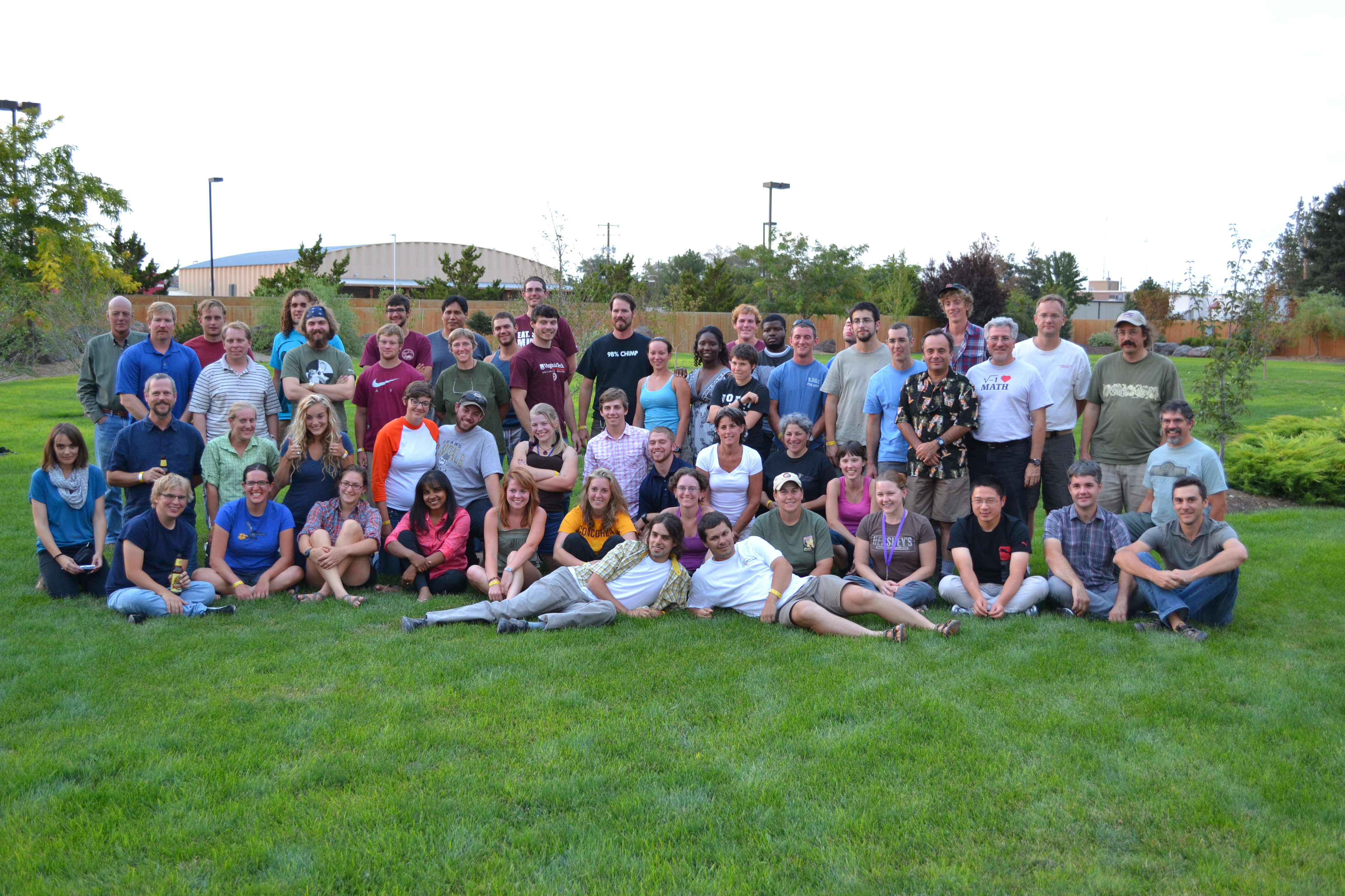 Most of the 61-person IDOR Controlled-Source Seismic crew were volunteers, mostly students, from 22 different universities.
 the shot loading and stemming crew, led by Steven Harder (professor at University of Texas, El Paso), in front of the explosives pump truck
 the survey crew, led by Kathy Davenport (graduate student at Virginia Tech), surveyed the seismometer sites prior to arrival of the deployment crew
 George Slad (staff at IRIS-PASSCAL) training the crew how to deploy a seismometer (ground shaking sensor - orange) and seismomograph (recording unit - in plastic bag; this device is nicknamed a "Texan")
 Strawberry Mountain, near Prairie City, Oregon; these mountains are comprised of island-arc terranes accreted to North America
 Maureen Kahn (undergrad volunteer from Carleton College) deploying a Texan seismograph in eastern Oregon
 Messan Folivi (undergrad volunteer from Southern University) deploying a Texan seismograph in western Idaho
 one of two occasions that a vehicle had 2 flat tires simultaneously; it was a ~5-hour walk out in 95-degree sun
 Ray Russo (IDOR project PI; professor at Univerity of Florida) enjoying the view from Snowbank Mountain, on the Western Idaho Shear Zone
 Rich Gaschnig (postdoc volunteer from the University of Maryland) meeting all Forest Service requirements for road work
 Basil Tikoff (IDOR project PI; professor at University of Wisconsin, Madison) and Annia Fayon (professor at University of Minnesota) teaching the crew about the Idaho Batholith and Western Idaho Shear Zone during a mid-project field trip
 Jennifer All (undergrad volunteer from Radford University) leading a crew of seismometer deployers on a 16-km hike, crossing the Deadwood River, Idaho
 the Halstead fire, central Idaho, as viewed from the seismic line; seismometers were not deployed as originally planned along the road in the foreground
 when picking up the Texan seismographs, one was found under a piece of heavy machinery; it can be seen poking out at the end of the shovel
 Borah Peak in the Lost River Range, eastern Idaho; the range front is the fault scarp of the 1983 magnitude 6.9 Borah Peak earthquake; this fault is actively extending
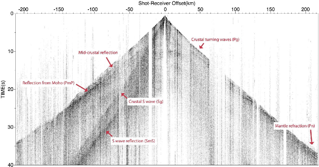 Band-pass filtered data from one shot.
The image shows strong P-wave and S-wave energy that has refracted (turned) in the crust,
energy that has reflected from the mid-crust and the Moho, and energy that has refracted in the uppermost mantle.
Band-pass filtered data from one shot.
The image shows strong P-wave and S-wave energy that has refracted (turned) in the crust,
energy that has reflected from the mid-crust and the Moho, and energy that has refracted in the uppermost mantle.